
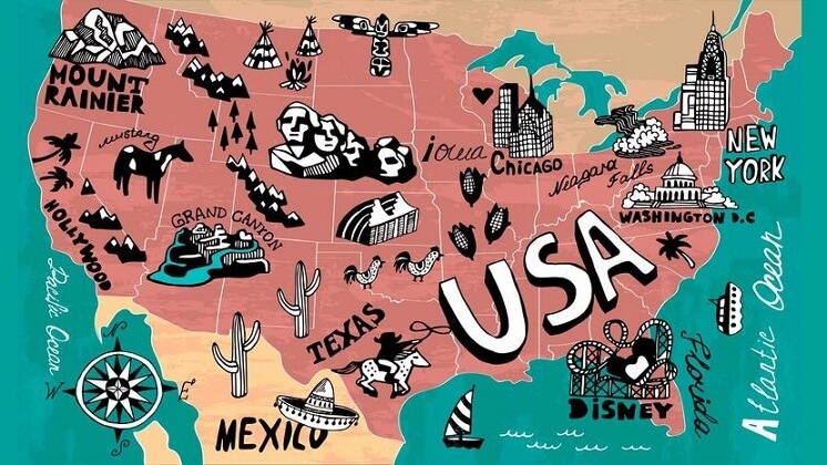
How Many States Are In The U.S.A.?
The United States currently has 50 states, including Alaska and Hawaii.
By: Sharise Cunningham | How Stuff Works
The United States is the third largest country in the world, just after Russia and Canada. The entire country has a total area of 3.8 million square miles (9.8 million square kilometres), according to the U.S. Census bureau. But how many states are in the U.S.A.?
Since 1959, 50 states have been part of the United States, not 52 as some might think. But the U.S. also includes the federal District of Columbia (Washington, D.C.), two commonwealths (Puerto Rico and the Northern Marianas Island) plus several inhabited territories (Guam, American Samoa and the U.S. Virgin Islands) and numerous uninhabited minor territories.
The 50 U.S. States & Capitals
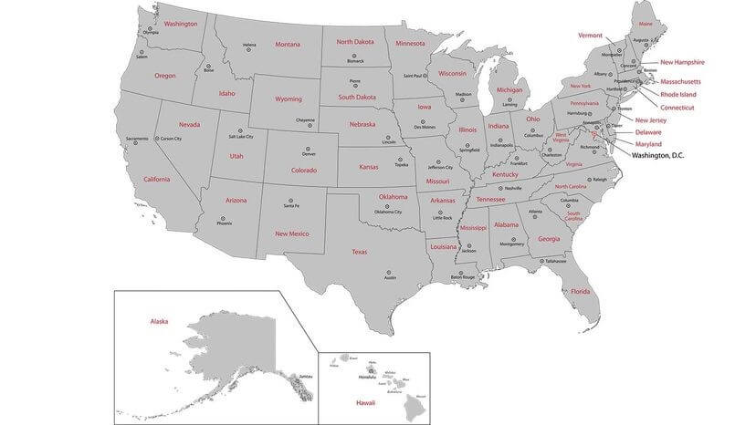
- Alabama (Montgomery): Alabama is 30th in size by land area, with a diverse topography of mountains, valleys and plateaus.
- Alaska (Juneau): Alaska is the largest state by land area. It lies at the extreme northwest of the North American continent. The Alaska Peninsula includes 14 large islands, 55 smaller ones and numerous islets.
- Arizona (Phoenix): Arizona is known for its deep canyons, high mountains, hot summers and barren deserts.
- Arkansas (Little Rock): Hot Springs National Park features bubbling hot water springs, which used to be popular for its healing properties.
- California (Sacramento): California is the most populous state, with 39.03 million people, according to the 2020 census.
- Colorado (Denver): This mountainous state encompasses rugged, mountainous terrain, as well as vast plains, desert lands/canyons and mesas.
- Connecticut (Hartford): This relatively flat state runs through the central valley and coastal plains. The few hills in the Northwest tend to have hardwood forests. The remaining two-thirds of the state is open land.
- Delaware (Dover): As one of the Mid-Atlantic States, Delaware is situated almost entirely on the north-eastern part of the Delmarva Peninsula, which formed over millions of years of high and low sea level fluctuations that lengthened the peninsula into a major barrier.
- Florida (Tallahassee): This peninsula lets you boat in the Gulf of Mexico on the West Coast and dip your toes in the sand of the Atlantic Ocean on the East Coast.
- Georgia (Atlanta): This southern state is home to five distinct physiographic provinces: the Appalachian Plateau, the Valley and Ridge, the Blue Ridge, the Piedmont Plateau and the Coastal Plain.
- Hawaii (Honolulu): The last state to join the U.S. includes misty plateaus, craggy ocean cliffs, tropical coastal areas, lava deserts and lush forests.
- Idaho (Boise): Idaho may be best known for potatoes, but it also contains the Snake River, which runs through Hells Canyon, the deepest gorge in the United States.
- Illinois (Springfield): Illinois lies midway between the Continental Divide and the Atlantic Ocean.
- Indiana (Indianapolis): This state borders Lake Michigan in the north-central United States. It’s quite flat with a variation in elevation of no more than 600 feet from its highest point.
- Iowa (Des Moines): It’s all about corn here … and college football. Iowa was officially designated the Hawkeye State in 1838, eight years before it even obtained statehood.
- Kansas (Topeka): This centrally located state is pretty flat and hosts grasslands, fertile soil, badlands, rolling hills, cuestas and canyons.
- Kentucky (Frankfort): Kentucky is the home of horse races and mint juleps. This commonwealth is 37th in land size at just 39,732 square miles (102,907 square kilometres).
- Louisiana (Baton Rouge): Louisiana is the only state in the country with “parishes” instead of counties.
- Maine (Augusta): Maine is the biggest and easternmost state in New England. It borders the Canadian provinces of Québec and New Brunswick.
- Maryland (Annapolis): One of the original 13 states, Maryland holds the distinction of being the defining line between north and south, commonly known as the Mason Dixon Line.
- Massachusetts (Boston): Another one of the original 13 states, Massachusetts is also a commonwealth.
- Michigan (Lansing): Michigan borders four of the five Great Lakes and has more than 10,000 lakes, as well as the longest freshwater shoreline in the world.
- Minnesota (St. Paul): Known as the “Land of 10,000 Lakes,” Minnesota has the most named lakes, around 15,291.
- Mississippi (Jackson): Other than being one of the hardest states to spell without a jingle, Mississippi is almost entirely within the Gulf coastal plain.
- Missouri (Jefferson City): The “Show-me State” is just about the geographical centre of the United States.
- Montana (Helena): This western state earns its nickname as “Big Sky Country” thanks to its vast and open spaces. It covers a land area of more than 147,000 square miles, making it the fourth largest state in the nation.
- Nebraska (Lincoln): Nebraska is the centre of the continental United States and is characterized by rolling hills and expansive plains.
- Nevada (Carson City): Nevada includes mountainous regions among vast, semi-arid grasslands and sandy deserts. And of course, Las Vegas.
- New Hampshire (Concord): As one of the original 13 states, New Hampshire was the first to declare its independence from England in 1775.
- New Jersey (Trenton): The Garden State is the fourth smallest state by land area.
- New Mexico (Santa Fe): This south-western state has more Ph.Ds. per capita than any other state.
- New York (Albany): Most of the state consists of farms, forests, rivers, mountains and lakes. It’s home to Adirondack Park, the largest National Park in the contiguous U.S.
- North Carolina (Raleigh): This south-eastern state is famous for being the home of the first flight.
- North Dakota (Bismarck): Among the quirky sites (or sights) here are the Enchanted Highway, a collection of the world’s largest scrap metal sculptures erected along a 32-mile stretch of highway.
- Ohio (Columbus): Eight U.S. presidents are from Ohio, and its name derives from the Iroquois word ohi-yo’, which means “great river.”
- Oklahoma (Oklahoma City): The Sooner State has the typical south-western terrain of mesas, canyons and grasslands.
- Oregon (Salem): This state borders the Pacific Ocean and is home to Portland, which has more breweries than any other city in the world (60-plus), per capita.
- Pennsylvania (Harrisburg): Cheesesteaks, chocolate and steel aside, Pennsylvania, another commonwealth, was the first to have a daily newspaper and a public zoo.
- Rhode Island (Providence): Despite being so small, Rhode Island has nearly 1.1 million people.
- South Carolina (Columbia): South Carolina was the first state to grow tea leaves in the lush Sea Islands region. The Atlantic Coastal Plain, Piedmont Plateau and Blue Ridge Mountains are its other regions.
- South Dakota (Pierre): Perhaps best known for Mount Rushmore in its Badlands, South Dakota actually has more shoreline than Florida.
- Tennessee (Nashville): Tennessee has some of the most varied geographic features in six main land regions: the Blue Ridge, Appalachian Ridge and Valley Region, Appalachian Plateau, Highland Rim, Nashville Basin and the Gulf Coastal Plain.
- Texas (Austin): Everything is bigger here, including cattle ranches and cowboy hats. But Texas also has grasslands, rolling hills, lakes, forests and a substantial coastline along the Gulf of Mexico.
- Utah (Salt Lake City): Utah is the 13th largest state in the country with 84,899 square miles (219,887 square kilometres) of land. And the federal government owns more than 60 percent of that.
- Vermont (Montpelier): Vermont is the home of maple syrup and the birthplace of Ben & Jerry’s ice cream.
- Virginia (Richmond): Virginia stretches along the Atlantic coastline from Chesapeake Bay to the Appalachian Mountains. One of the 13 original colonies, it is home to many of the nation’s historic landmarks.
- Washington (Olympia): The most north-western state in the Pacific Northwest shares a border with Canada. This proximity and its own islands means it’s home to the largest ferry fleet in the U.S.
- West Virginia (Charleston): The coal industry has blighted much of the beauty, but West Virginia will forever be the only state completely within the Appalachian Mountain range.
- Wisconsin (Madison): This state has shorelines on two Great Lakes (Michigan and Superior) and an interior of forests and farms. It’s known for cheese, beer and the Harley-Davidson Museum.
- Wyoming (Cheyenne): This state has the lowest population with about 581,000 residents scattered across 97,814 square miles (253,340 square kilometres). It was the first state to grant women the right to vote and, fittingly, the first state to have a female governor.
How a Territory Becomes a State
Thirty-two U.S. territories have already become states, including Hawaii. President William McKinley urged the United States to annex Hawaii in 1898. Hawaii became a territory in 1900 and eventually a state in 1959. So how do territories become states? It’s written right in the Constitution:
New States may be admitted by the Congress into this Union; but no new States shall be formed or erected within the Jurisdiction of any other State; nor any State be formed by the Junction of two or more States or parts of States, without the Consent of the Legislatures of the States concerned as well as of the Congress.
But before even that, Congress must establish an organic act, which is an act that establishes a territory of the United States and specifies how it is to be governed. Organic acts also can create agencies to manage certain federal lands. For example, the Organic Act of 1890 created separate Oklahoma and Indian Territories, and the Organic Act of 1916 established the National Park Service (NPS) and National Park System.
Now That’s Interesting
The federal District of Columbia (Washington, D.C.) could one day be a state if the push for statehood ever succeeds. As of this writing, there are also 14 official territories, only five of which are permanently inhabited (American Samoa, Guam, Northern Mariana Islands, Puerto Rico and the U.S. Virgin Islands).
* * *
READ MORE: What’s Attracting So Many People to Magnet Fishing?
Read more on Modern Era News: Meet The Line, Saudi Arabia’s Future 106-Mile, One-Building City
Liked it? Take a second to support Collective Spark.
We’d love to hear from you! If you have a comment about this article or if you have a tip for a future Collective Spark Story please let us know below in the comment section.