By Joseph D. Brown | The Mind Unleashed
Rains associated with the monsoon season are nothing new for Pakistan. They are able to make a note of it on the calendar between the months of June and September. But the rainfall just kept coming and coming throughout this year. This is some of the worst flooding Pakistan has ever seen.
The rains were so bad that the water just has nowhere to go.
🧵🧵🧵: Pakistani floods will likely reshape global ag markets and the regional security order.
Flooding in Pakistan is truly biblical.1/3 of the country is underwater. 33 million – 15% of the population – are impacted.
It also harms production of wheat, rice, and cotton. 1/n pic.twitter.com/qXJBDuIWDH
— Nathan Carson (@ndcarson) September 4, 2022
“The Pakistani people are facing a monsoon on steroids, the relentless impact of epochal levels of rain and flooding,” Antonio Guterres, the Chief of the United Nations, said in a video statement. “This climate catastrophe has killed more than 1,000 people with many more injured.”
Hard to comprehend the scale of the flood disaster in Pakistan, the 5th most populated nation in the world.
Nearly 1400 dead, 1 million houses damaged or destroyed, and 50,000,000 people displaced.
1/3 of the country is underwater.pic.twitter.com/NFd15q3g7I
— Colin McCarthy (@US_Stormwatch) August 30, 2022
According to NASA, many regions have already received five to six times the amount of rainfall that is typical for a whole year. This is an astounding number when one considers that the data used to calculate the average spans a period of thirty years and includes the information from 2010, the year in which the county saw the worst monsoon floods in its entire recorded history that killed over 2000 people.
Pakistan’s flood crisis is an unprecedented climate change catastrophe but barely creating a ripple in Western media, excluding online reports.
This is racism, pure and simple. And if you don’t believe me, then contrast this to media coverage of 2020 Australian bushfires.
— CJ Werleman (@cjwerleman) September 4, 2022
Pakistan floods have:
•Killed 1300+ people
•Displaced 50M people
•Killed 80% of the livestock
•Submerged 33% of the country
•Entirely destroyed 600K homesIf Pakistan were a Western nation we’d see 24/7 coverage
Pakistanis need us. Pls RT & Donate:https://t.co/apl7KD0twx
— Qasim Rashid, Esq. (@QasimRashid) September 2, 2022
Pakistan's devastating floods:
– 1350 people killed
– 50M people displaced
– 900K livestock deaths
– 1M houses washed away
– 40+ reservoirs breached
– 220+ bridges collapsed
– 90% cropped damaged
– $10B loss to economy
– 1/3 country underwaterSource – PDMA / NDMA pic.twitter.com/TG6jnL8zZQ
— South Asia Index (@SouthAsiaIndex) August 29, 2022
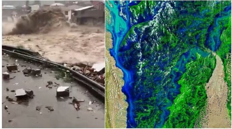
The floods in Pakistan are currently so bad that an ocean seems to be forming within the country. Here are satellite images showing the before and after. pic.twitter.com/dGokxAC3yG
— Aslan Pahari (@aslanpahari) September 2, 2022
The floods in Pakistan… 😢
pic.twitter.com/RqKrpUFQjy— Tarek Fatah (@TarekFatah) September 6, 2022
The melting of mountain snow and glaciers has only made the problem worse. According to NASA, Pakistan has the largest concentration of glacier ice that can be found outside of the polar regions. Mountain Rivers get clogged with runoff as a result of precipitation during the monsoon season and melting snow, which then causes landslides to occur.
During the same time that the Disasters Emergency Committee (DEC) of the United Kingdom issued an appeal to collect funding for the 33 million people impacted by the disaster, the European Space Agency (ESA) published striking photos based on data obtained by its Copernicus satellite.
At the end of September, according to forecasts from the Pakistan Meteorologist Department, the monsoon season should begin to wind down.
From outer space, satellites were able to capture evidence of the record deluge. The magnitude of the damage caused by this year’s monsoon floods can be seen in images released by both Maxar and NASA.
As fresh satellite photographs seemed to reveal that a third of the country is now inundated with water, aid workers urged for immediate contributions to combat the “absolutely devastating” effect of the floods, the Guardian reports.
During the same time that the Disasters Emergency Committee (DEC) of the United Kingdom issued an appeal to collect funding for the 33 million people impacted by the disaster, the European Space Agency (ESA) published striking photos based on data obtained by its Copernicus satellite.
The false-colour photos that are seen above were obtained on August 4 and 28, respectively, by the Operational Land Imagers that are carried on board the Landsat 8 and Landsat 9 satellites. The photos use a combination of shortwave infrared, near infrared, and red light (bands 6-5-4) to improve the ability to differentiate flood waters (dark blue) outside of their native routes. (Image credit: NASA Earth Observatory pictures by Joshua Stevens, utilizing data from Landsat collected by the United States Geological Survey and VIIRS data collected by NASA EOSDIS LANCE, GIBS/Worldview, and the Joint Polar Satellite System (JPSS))
According to a report by NPR, the flooding in Pakistan has impacted more than 33 million people and caused more than 1,100 deaths since the middle of June, including hundreds of children. The flooding was caused by extremely strong monsoon rains… The floods have caused damage to over one million houses, as well as millions of acres of agriculture, hundreds of kilometres of highways, and other infrastructure.
Satellite photos that were released on the 28th of August by the NASA Earth Observatory (opens in new tab) highlighted how the floods had altered the terrain throughout the nation between the beginning and end of the month of August.

